Block, site and location plans – what is the difference?
When you submit a planning application, the local planning authority (LPA) needs to understand where the site is and how it relates to the surrounding area. As a general rule you will require both a Location Plan and Site or Block Plan. Both of these will be to different scales.
Prior to submitting the application we recommend searching for a validation checklist for the local authority. Within Google you can search for “<your local authority> validation checklist” – if such a list exist, you can see exactly what they require. If no such list exists, we recommend supplying both a location and site plan.
Location Plans
Most planning applications need a location plan which shows the proposed project in the context of its surroundings. A site location plan is drawn to a metric scale, which shows the property where planning permission is sought and the surrounding areas. It must be based on an up-to-date Ordnance Survey map. Site location plans should clearly show the location and boundaries of the proposed (and entire) development site.
- Should be at an identified standard metric scale (typically 1:1250 for urban applications or 1:2500 for rural or larger sites)
- The direction of north must be clearly marked
- It should be scaled to fit on either A4 or A3 paper
- Should show the date of survey or an Ordnance Survey Licence number if appropriate
- Identify sufficient roads and/or buildings on nearby land to ensure that the exact location of the application site is clear. For example, in rural areas you will normally need to show two named roads.
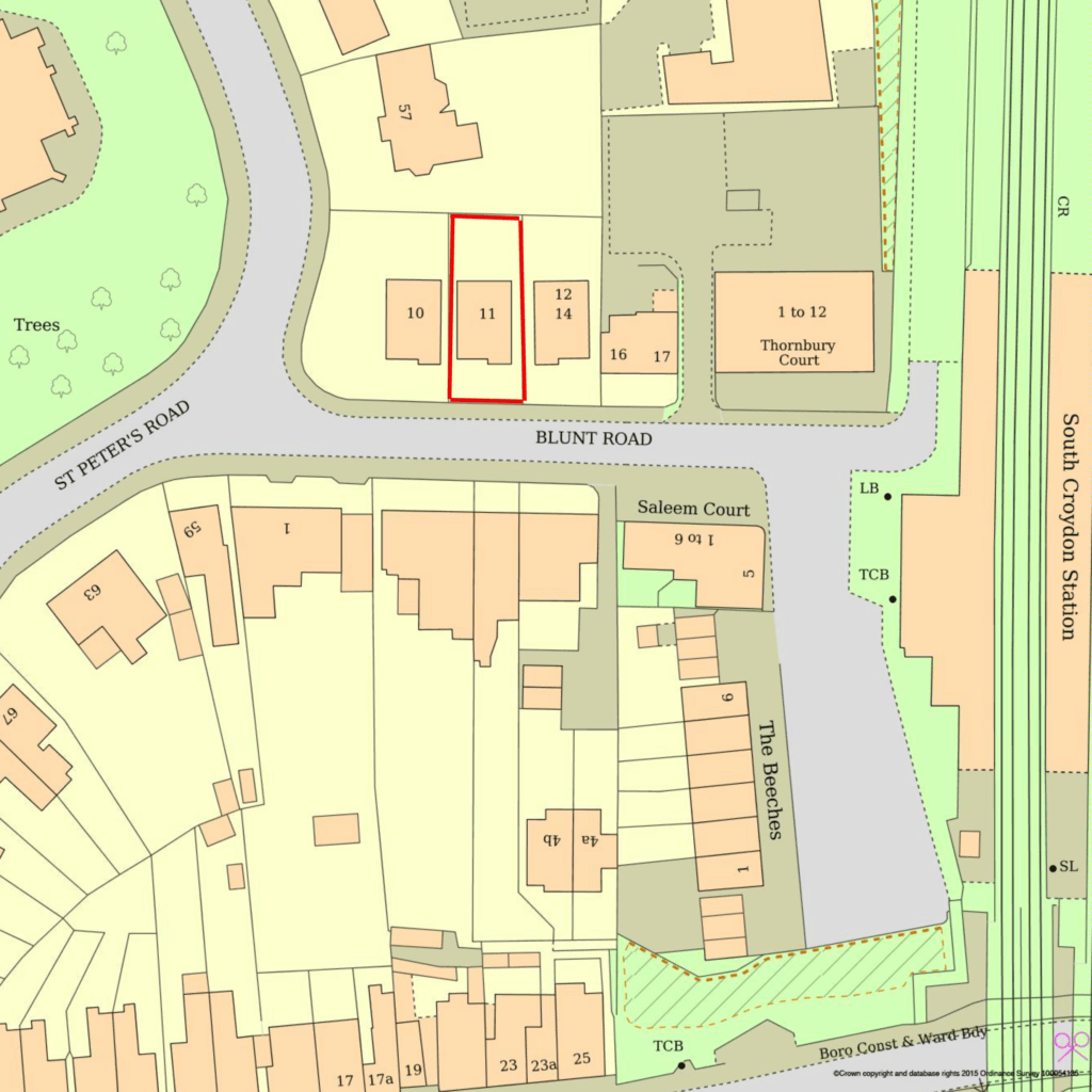
- Show application site boundary and all land necessary to carry out the proposed development i.e. land required for access to the site from the road, outlined in red
- A blue line should be drawn around any other land owned by the applicant, close to or adjoining the application site – although this is optional

Example of a location plan – note that certain required elements are not shown
Site or Block Plans
The site plan (also called a “block plan”) is a zoomed in version of the location plans showing the proposed development in greater detail. It should be drawn at an identified standard metric scale – this is normally 1:200 or 1:500. It should show the proposed development in relation to the site boundaries and other existing buildings on the site, with dimensions specified including those to the boundaries. This is often not essential to an application. But for more complex sites, it will be. However if the validation checklist requires it, you must supply in order to pass the validation requirements.
It should also include the following – unless they would NOT influence or be affected by the proposed development.
- Should be at an identified standard metric scale (typically 1:200 for urban applications or 1:500 for rural or larger sites)
- The direction of north must be clearly marked
- It should be scaled to fit on either A4 or A3 paper
- Plot boundary marked in a red line
- A blue line should be drawn around any other land owned by the applicant, close to or adjoining the application site – although this is optional
- All buildings, roads and footpaths on land adjoining the site including access arrangements.
- All public rights of way crossing or adjoining the site.
- The extent and the type of any hard surfacing
- The boundary treatment including walls or fencing where this is proposed.
- Any trees on the site
For most basic applications it will not be necessary to show trees etc. If the application does affect these, perhaps a new build, then we recommend getting an architect to draw this up as more detail will be required.
You can obtain plans from a number of online suppliers. UK Planning Maps is one option. We can also assist here at Planning Geek.
Page Updated: 28th March 2024
Other Planning Application Sections